| Hike | Locatie | Afstand mijl / km | Hoogteverschil voet / meter | Gewandelde tijd |
|---|---|---|---|---|
| Upper Yosemite Trail | Yosemite NP | 7,2 / 11,6 | 2.700 / 823 | 5:45 |
| Brokeoff Mountain Trail | Lassen Volcanic NP | 7 / 11,3 | 2.600 / 792 | 4:00 |
| Bright Angel Trail | Grand Canyon NP | 12,2 / 19,6 | 3.015 / 919 | 6:30 |
| Mt Diablo Summit | Mount Diablo SP | 14 / 22.5 | 3.269 / 996 | 6:00 |
| Nevada Fall | Yosemite NP | 8.5 / 13.7 | 1.872 / 571 | 4:00 |
| Snow Creek | Yosemite NP | 7.8 / 12.5 | 2.911 / 887 | 5:00 |
| Lakes Trail | Sequoia NP | 7.8 / 12.5 | 2.314 / 705 |

Directions to trailhead:
You can either drive from Yosemite Village to Camp 4 and park at the Yosemite Lodge or take the Yosemite Valley Shuttle to stop 7. The trail starts behind the parking lot of Camp 4.
Trail description:
The trail leaves from Camp 4 immediately into a forest with lots of switchbacks. When the trail gets more sandy it's an indication that you're approaching Columbia Rock. From there the hike will bring you closer to the fall and after a nice view on the fall you'll reach a more rocky section with several switchbacks (in our opinion the most difficult part). Once you cross Yosemite Creek there's only a short walk left to reach the amazing views over the valley from the top of Yosemite Fall.
Link to blogpost:
Trip Yosemite National Park
Top of page
Brokeoff Mountain Trail
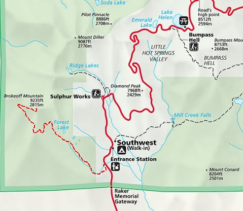
Directions to trailhead:
The trail starts at the parking lot along Hwy 89 about 1/2 mile before the Southwest Entrance Station to Lassen Volcanic NP.
Trail description:
From the parking lot cross the road and follow the trail shortly away from the mountain. The trail will slowly start curving northwest into a pine forest and down the road you will pass a small lake before arriving in the open with stunning views on Brokeoff Mountain. When the trail makes a 180 degree turn to the southeast you know that you're getting close to the summit.
Link to blogpost:
Kampeertrip Lassen Volcanic National Park
Top of page
Bright Angel Trail

Directions to trailhead:
From the South Entrance Station you can either follow the Center Road or the South Entrance Road (past the Visitor Center and Market Plaza) to the Bright Angel Lodge. In case the parking is full drive towards the Maswik Lodge on the other side of the railway for additional parking. The trailhead starts behind the bus stop left of the Kolb Studio.
Trail description:
Link to blogpost:
Roadtrip parents: Grand Canyon
Top of page
Mt Diablo Summit

Directions to trailhead:
From the city of Clayton follow the Mitchell Canyon Road all the way till the end. There is a $6 entrance fee to get to the parking lot and the trail starts next to the visitor center.
Trail description:
Follow Mitchell Canyon Rd to Deer Flat. Then Deer Flat Rd till you arrive at Juniper Campground. Cross the campground and continue on Juniper Trail until you arrive at the Lower Summit parking lot. Follow the road uphill to get to the summit. Return to the lower parking lot and follow the Summit Trail to Devils Elbow where you continue on the North Peak Trail. Once you arrive at Prospectors Gap take the Bald Ridge Trail to Murchio Gap. Descend Back Creek Trail for about 2 miles until the junction with Bruce Lee Rd. Follow Bruce Lee Rd shortly and turn onto Coulter Pine Trail to get back to the parking lot at Mitchell Canyon Road.
Link to blogpost:
Mt. Diablo & Point Reyes
Top of page
Nevada Fall

Directions to trailhead:
Follow the signs "Curry Village" and park your car on the trailhead parking lot or Curry Village parking lot. From there you can either walk towards the Nature Center at Happy Isles or take the Shuttle to stop 16.
Trail description:
The first part of the trail from Shuttle stop 16 is rather flat. Immediately after crossing the Merced river for the first time turn left and follow the Mist Trail till you reach the top of Vernall Fall. Be sure to bring a raincoat as you might get real wet in this part of the hike. The trail from Vernall to Nevada Fall is less crowded but consists of a lot of switchbacks. If you don't want to return to Yosemite Valley via the Mist Trail, you can descend via the John Muir Trail but make sure to turn around and observe the amazing view on Half Dome and Nevada Fall.
Link to blogpost:
"Memorial Day"-weekend in Yosemite
Top of page
Snow Creek

Directions to trailhead:
Follow the signs "Curry Village" and park your car on the trailhead parking lot or Curry Village parking lot. From there you can either walk towards Mirror Lake or take the Shuttle to stop 17. For the shortest walk from the parking lot to Mirror Lake, you need to cross the Merced River between Upper and Lower Pines Campground and follow the road in E direction till Shuttle stop 17.
Trail description:
From the shuttle stop follow the path towards Mirror Lake. Continue along the Loop Trail past Mirror Lake and through the forest till you get to a junction where you have to follow the trail on the left hand side. Shortly after turning left there will be series of switchbacks that will take you to the open from where you have stunning views on the Valley floor, Half Dome and Tenaya Falls. When you arrive at level terrain after a second series of switchbacks, you know that it's only a short walk to arrive at the Snow Creek Footbridge. When we did the hike there was still quite a bit of snow and temperatures were low but we can imagine spending some time exploring this area.
Link to blogpost:
"Memorial Day"-weekend in Yosemite
Top of page
Lakes Trail


Directions to trailhead:
Follow Generals Highway from Big Stump Entrance (N) all the way passed Lodgepole. Turn into the next street on your left towards Wolverton. When you're entering from Ash Mountain Entrance (S) the Generals Highway and turn into the first street on the right after you passed the General Sherman Tree. Follow the road till you arrive at Wolverton where you turn left onto the parking lot. The trail leaves halfway down the parking lot on the left hand side.
Trail description:
Immediately after leaving the parking lot, you will get into the forest where you relative quickly have to make a right turn to start a nice climb. After a mile you will walk along Wolverton Creek on your right hand side. You will reach the junction with Panther Gap Trail about 1.75 mile out and shortly thereafter the junction of Watchtower and Hump Trail. Before reaching the Hump you'll need to gain over 1,000 feet of elevation but the view from the summit are worthwile. From the Hump it's only a short 0.25 descend to Heather Lake.
Link to blogpost:
Kampeerweekend Kings Canyon & Sequoia NP
Top of page
Geen opmerkingen:
Een reactie posten